High-resolution images will play critical role in numerous UAE civilian programmes
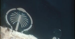
DubaiSat-1, the UAE’s first satellite, has transmitted its first series of UAE images from orbit, including a snapshot of the Palm Jebel Ali. The Emirates Institution for Advanced Science & Technology (EIAST) received the images earlier today.
His Excellency Ahmed Al Mansoori, Director General of EIAST, said the successful images are an indication of diverse capabilities to be realized imminently.
 “These quality images of relevant phenomena such as the Palm Jebel Ali are the first fruits of DubaiSat-1. After processing and analysis, the satellite’s images will provide information and data that serve the UAE’s development and assist in decision-making. EIAST will work with various government authorities and establishments to deliver the needed imaging,†he said.
The delivery of the images from the orbiting satellite confirms the safety and efficiency of DubaiSat-1’s operational processes, Al Mansoori added. “DubaiSat-1 is operating ahead of schedule, and will continue to capture and deliver images for use in all UAE civilian and environmental programmes,†he said.
The DubaiSat-1 launch consists of two segments: space and ground. The space segment comprises the development, design and manufacture of satellite equipment and components of the measurement and imaging.The ground segment includes the mission control station, image receiving and processing station, antenna and RF subsystem. Images from DubaiSat-1 can be used for a variety of applications from urban development, scientific research, telecommunications, transportation to civil engineering & constructions, mapping and GIS.
The DubaiSat-1 is the first remote sensing satellite owned by the UAE which represents the country’s determination to possess advanced space technologies to fulfil the needs of scientific and technological research, as well as to provide up-to-date spatial and earth monitoring data that aids the holistic growth drive adopted by the nation.


